
Related Images


Download:
| Tiny | 104x128 | View | Download |
| Small | 208x256 | View | Download |
| Medium | 417x512 | View | Download |
| Large | 835x1024 | View | Download |
| Original | 4000x4905 | View | Download |
This image was acquired from
wikimedia. It was marked as Public Domain or CC0 and is free to use. To verify, go to the source and check the information there.
Looking for more info about this image?
Try a Google Reverse Image Search for it.
Try a Google Reverse Image Search for it.
Keywords from Image Description:
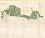
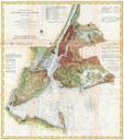
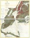
U.S. Coast Survey Map of St. Louis Bay and Shieldsboro Harbor Mississippi Geographicus StLouisBayMSuscs. An attractive hand colored Coast Survey triangulation chart or map of St Louis Bay Mississippi Details the area around St Louis Bay including the town of Shieldsboro modern St Louis Bay and Pass Christian Mississippi Details