
Related Images

Download:
| Tiny | 163x128 | View | Download |
| Small | 326x256 | View | Download |
| Medium | 652x512 | View | Download |
| Large | 1304x1024 | View | Download |
| Original | 3092x2428 | View | Download |
This image was acquired from
wikimedia. It was marked as Public Domain or CC0 and is free to use. To verify, go to the source and check the information there.
Looking for more info about this image?
Try a Google Reverse Image Search for it.
Try a Google Reverse Image Search for it.
Keywords from Image Description:
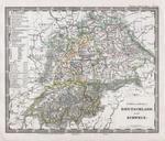
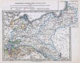
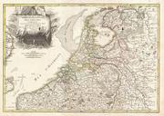
Stieler Map of Holland Belgium and Western Germany Geographicus DeutNiederlandeperthes. This fascinating map by Justus Perthes and Stieler depicts Holland the Netherlands and Belgium as well as parts of western Germany Statistical information to the bottom and left of the map proper Unlike other cartographic publishers of the