
Related Images


Download:
| Tiny | 166x128 | View | Download |
| Small | 333x256 | View | Download |
| Medium | 667x512 | View | Download |
| Large | 1335x1024 | View | Download |
| Original | 5000x3835 | View | Download |
This image was acquired from
wikimedia. It was marked as Public Domain or CC0 and is free to use. To verify, go to the source and check the information there.
Looking for more info about this image?
Try a Google Reverse Image Search for it.
Try a Google Reverse Image Search for it.
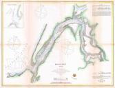
Keywords from Image Description:
U.S. Coast Survey Map of Coos Bay Oregon Geographicus KoosBayOregonuscs. very nice example of the Coast Survey's map or chart of Coos Bay Koos Bay Oregon Details the shaped inlet as far as the Coos River Identifies Empire City Marshfield Point and other destinations Marshfield was later renamed Coos Bay and has become one of