
Related Images


Download:
| Tiny | 184x128 | View | Download |
| Small | 368x256 | View | Download |
| Medium | 736x512 | View | Download |
| Large | 1473x1024 | View | Download |
| Original | 1614x1122 | View | Download |
This image was acquired from
wikimedia. It was marked as Public Domain or CC0 and is free to use. To verify, go to the source and check the information there.
Looking for more info about this image?
Try a Google Reverse Image Search for it.
Try a Google Reverse Image Search for it.
Keywords from Image Description:
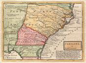
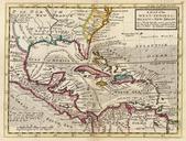
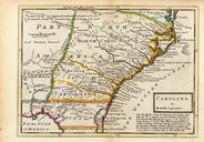
Map of the Carolinas by Herman Moll .jpeg en Map from published in London of the Carolinas from southern Virginia to northern Florida The ocean off the Carolinas is labeled as The Western Ocean indicating the perspective of its English author learnnc org Creator Herman Moll published by Thomas and John Bowles London PDold Old