Related Images


Download:
| Tiny | 173x128 | View | Download |
| Small | 347x256 | View | Download |
| Medium | 694x512 | View | Download |
| Large | 1388x1024 | View | Download |
| Original png | 1906x1406 | View | Download |
| Original as jpg | 1906x1406 | View | Download |
This image was acquired from
wikimedia. It was marked as Public Domain or CC0 and is free to use. To verify, go to the source and check the information there.
Looking for more info about this image?
Try a Google Reverse Image Search for it.
Try a Google Reverse Image Search for it.
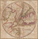
Keywords from Image Description:
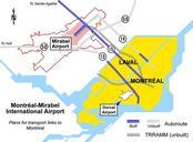
Mirabelintlarpttransportlinks. Map showing initial plan for transport links serving the area around MontrealMirabel International Airport The was originally planned to bypass Mirabel to the south whereas today's goes through Mirabel Also the TRRAMM line is shown separately from the DeuxMontagnes commuter rail line which itself was