
Related Images


Download:
| Tiny | 91x128 | View | Download |
| Small | 183x256 | View | Download |
| Medium | 367x512 | View | Download |
| Large | 734x1024 | View | Download |
| Original | 1993x2780 | View | Download |
This image was acquired from
wikimedia. It was marked as Public Domain or CC0 and is free to use. To verify, go to the source and check the information there.
Looking for more info about this image?
Try a Google Reverse Image Search for it.
Try a Google Reverse Image Search for it.
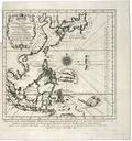
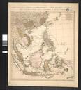
Keywords from Image Description:
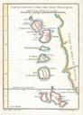
Bellin Map of the Moluques Moluccas Moluccan Island Geographicus Moluquesbellin. This beautiful hand colored map of the Moluques also known as the Moluccas Moluccan Islands or simply Maluku was produced by the French Cartographer JacquesNicolas Bellin in Depicts the islands of Herij Ternate Tidor Pottebackers Timor Machian