
Related Images


Download:
| Tiny | 160x128 | View | Download |
| Small | 320x256 | View | Download |
| Medium | 640x512 | View | Download |
| Large | 1281x1024 | View | Download |
| Original | 3500x2797 | View | Download |
This image was acquired from
wikimedia. It was marked as Public Domain or CC0 and is free to use. To verify, go to the source and check the information there.
Looking for more info about this image?
Try a Google Reverse Image Search for it.
Try a Google Reverse Image Search for it.
Keywords from Image Description:
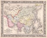
Mitchell Map of China Geographicus Chinamitchell. An extremely attractive example of Mitchell Sr map of China Covers from Chinese Tartary south to Hainan and east to Korea and Formosa Chinese provinces are color coded and numbered Surrounded by the green border common to Mitchell maps from the Prepared by Mitchell for issued as