
Related Images


Download:
| Tiny | 101x128 | View | Download |
| Small | 203x256 | View | Download |
| Medium | 407x512 | View | Download |
| Large | 814x1024 | View | Download |
| Original | 3059x3848 | View | Download |
This image was acquired from
wikimedia. It was marked as Public Domain or CC0 and is free to use. To verify, go to the source and check the information there.
Looking for more info about this image?
Try a Google Reverse Image Search for it.
Try a Google Reverse Image Search for it.
Keywords from Image Description:
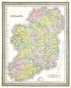
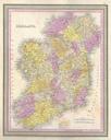
Mitchell Map of Ireland Geographicus Irelandmitchell. This hand colored map is lithographic engraving of Ireland dating to by the American map publisher Mitchell the elder Topographical information is clearly presented and towns lakes roads and other information is shown and named Political divisions are indicated with contrasting