
Related Images


Download:
| Tiny | 105x128 | View | Download |
| Small | 211x256 | View | Download |
| Medium | 423x512 | View | Download |
| Large | 846x1024 | View | Download |
| Original | 3619x4377 | View | Download |
This image was acquired from
wikimedia. It was marked as Public Domain or CC0 and is free to use. To verify, go to the source and check the information there.
Looking for more info about this image?
Try a Google Reverse Image Search for it.
Try a Google Reverse Image Search for it.
Keywords from Image Description:
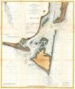
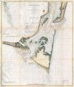
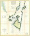
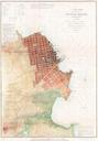
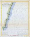
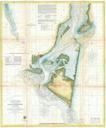
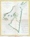
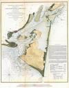
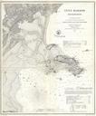
U.S.C.S. Map of Cape Charles and Vicinity Virginia Geographicus CapeCharlesuscs. rare hand colored coastal chart Cape Charles Virginia Cape Charles forms the southeastern tip of the peninsula formed by the Chesapeake Bay At one time it was an important stop on the railroad and still serves as ferry base for crossing the bay In


