
Related Images


Download:
| Tiny | 97x128 | View | Download |
| Small | 194x256 | View | Download |
| Medium | 389x512 | View | Download |
| Large | 779x1024 | View | Download |
| Original | 3046x4000 | View | Download |
This image was acquired from
wikimedia. It was marked as Public Domain or CC0 and is free to use. To verify, go to the source and check the information there.
Looking for more info about this image?
Try a Google Reverse Image Search for it.
Try a Google Reverse Image Search for it.
Keywords from Image Description:
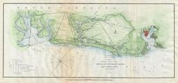
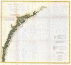
U.S. Coast Survey Map of Cape Lookout North Carolina Geographicus CapeLookoutuscs. An extremely attractive Coast Survey nautical chart or map detailing Cape Lookout North Carolina and nearby shoals Map shows the land projection of Cape Lookout and much of the sea to the south and east Follows the course of the Nine Fathom Curve