
Related Images
Download:
| Tiny | 153x128 | View | Download |
| Small | 307x256 | View | Download |
| Medium | 615x512 | View | Download |
| Large | 1231x1024 | View | Download |
| Original | 3068x2551 | View | Download |
This image was acquired from
wikimedia. It was marked as Public Domain or CC0 and is free to use. To verify, go to the source and check the information there.
Looking for more info about this image?
Try a Google Reverse Image Search for it.
Try a Google Reverse Image Search for it.
Keywords from Image Description:
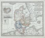
Stieler Map of Denmark Geographicus Danemarkperthes. This fascinating map by Justus Perthes and Stieler depicts Denmark Schleswig Holstein Iceland and the Faeroe Islands There are inset maps of Ireland and the Faeroe Islands In display of cartographic flair unique to Perthes maps land elevation profile is depicted on the bottom