
Related Images


Download:
| Tiny | 81x128 | View | Download |
| Small | 163x256 | View | Download |
| Medium | 326x512 | View | Download |
| Large | 653x1024 | View | Download |
| Original | 2552x4000 | View | Download |
This image was acquired from
wikimedia. It was marked as Public Domain or CC0 and is free to use. To verify, go to the source and check the information there.
Looking for more info about this image?
Try a Google Reverse Image Search for it.
Try a Google Reverse Image Search for it.
Keywords from Image Description:
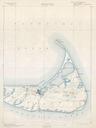
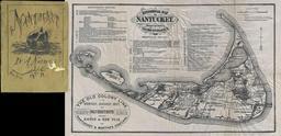
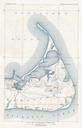
U.S. Geological Survey Map of Nantucket Massachusetts Geographicus NantucketUSCS. This is an unusual chart of Nantucket Massachusetts published by the Geological Survey Depicts the western part of the island in incredible detail with even individual buildings noted This is map is reduction of an early Geological Survey chart of