
Related Images


Download:
| Tiny | 93x128 | View | Download |
| Small | 186x256 | View | Download |
| Medium | 372x512 | View | Download |
| Large | 744x1024 | View | Download |
| Original | 4363x6000 | View | Download |
This image was acquired from
wikimedia. It was marked as Public Domain or CC0 and is free to use. To verify, go to the source and check the information there.
Looking for more info about this image?
Try a Google Reverse Image Search for it.
Try a Google Reverse Image Search for it.
Keywords from Image Description:
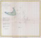
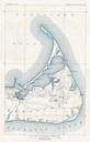
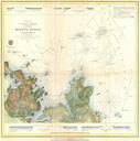
U.S. Coast Survey Chart or Map of Nantucket Island Massachusetts Geographicus Nantucketuscs. scarce and exceptional example of the Coast Survey chart or map of Nantucket The is the eastern sheet of three map set and is rarely offered separately The this map no in the series covers the island of Nantucket and the southern part