
Related Images


Download:
| Tiny | 176x128 | View | Download |
| Small | 352x256 | View | Download |
| Medium | 704x512 | View | Download |
| Original | 1100x800 | View | Download |
This image was acquired from
wikimedia. It was marked as Public Domain or CC0 and is free to use. To verify, go to the source and check the information there.
Looking for more info about this image?
Try a Google Reverse Image Search for it.
Try a Google Reverse Image Search for it.
Keywords from Image Description:
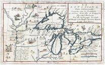
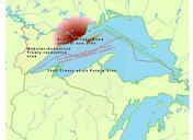
IsleRoyaleAgreement. Map of Lake Superior region showing the WebsterAshburton Treaty area and the Treaty of La Pointe area their overlap over Isle Royale which precipitated the need for the Isle Royale Agreement with the adhesion of the Grand Portage Band to the Treaty of La Pointe Own CJLippert Ojibwe maps Maps of Ontario Maps