
Related Images


Download:
| Tiny | 74x128 | View | Download |
| Small | 149x256 | View | Download |
| Medium | 299x512 | View | Download |
| Large | 599x1024 | View | Download |
| Original | 2000x3416 | View | Download |
This image was acquired from
wikimedia. It was marked as Public Domain or CC0 and is free to use. To verify, go to the source and check the information there.
Looking for more info about this image?
Try a Google Reverse Image Search for it.
Try a Google Reverse Image Search for it.
Keywords from Image Description:
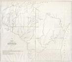
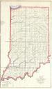
Public Survey Map of Indiana Geographicus INls. This magnificent map of Indiana was issued for the Land Survey Office under the supervision of Mc Clelland It is officially entitled Sketch of the Public Survey in Indiana In the southeast near Louisville Clark Grant is labeled This was the territory set aside by Thomas Jefferson