
Related Images


Download:
| Tiny | 113x128 | View | Download |
| Small | 226x256 | View | Download |
| Medium | 452x512 | View | Download |
| Large | 904x1024 | View | Download |
| Original | 4000x4529 | View | Download |
This image was acquired from
wikimedia. It was marked as Public Domain or CC0 and is free to use. To verify, go to the source and check the information there.
Looking for more info about this image?
Try a Google Reverse Image Search for it.
Try a Google Reverse Image Search for it.
Keywords from Image Description:
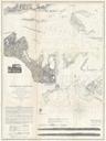
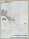
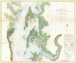
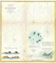
U.S. Coast Survey Map or Chart of Sow and Pigs Reef off Marthas Vineyard Massachussetts Geographicus SowandPigsReefuscs. This is an unusual Coast Survey chart of the Sow and Pigs Reef located just off Cuttyhunk near Martha Vineyard Massachusetts Chart depicts the site of proposed lighthouse on Saddle Rock An inset in the lower