
Related Images


Download:
| Tiny | 231x128 | View | Download |
| Small | 462x256 | View | Download |
| Medium | 925x512 | View | Download |
| Large | 1851x1024 | View | Download |
| Original | 5000x2765 | View | Download |
This image was acquired from
wikimedia. It was marked as Public Domain or CC0 and is free to use. To verify, go to the source and check the information there.
Looking for more info about this image?
Try a Google Reverse Image Search for it.
Try a Google Reverse Image Search for it.
Keywords from Image Description:
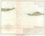
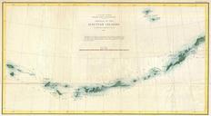
U.S. Coast Survey Map of the Aleutian Islands Alaska Geographicus AleutianIslandsuscs. This unusual map is the Coast Survey first significant mapping of the Aleutian Islands following the acquisition of the Alaska territory from Russia The map covers the Aleutian Archipelago from Atta Island to Unimak Island and extends far enough