
Related Images


Download:
| Tiny | 160x128 | View | Download |
| Small | 321x256 | View | Download |
| Medium | 643x512 | View | Download |
| Large | 1286x1024 | View | Download |
| Original | 3500x2786 | View | Download |
This image was acquired from
wikimedia. It was marked as Public Domain or CC0 and is free to use. To verify, go to the source and check the information there.
Looking for more info about this image?
Try a Google Reverse Image Search for it.
Try a Google Reverse Image Search for it.
Keywords from Image Description:
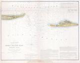
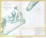
U.S. Coast Survey Map of Horn Island Pass Mississippi Sound Geographicus HornIslandPassuscs. very nice example of the Coast Survey chart or map of the Horn Island Pass Depicts the East End of Horn Island and the West End of Petit Bois Island with Horn Island Pass running between the two Horn Island Pass offers an exceptionally