
Related Images


Download:
| Tiny | 101x128 | View | Download |
| Small | 202x256 | View | Download |
| Medium | 404x512 | View | Download |
| Large | 809x1024 | View | Download |
| Original | 1020x1291 | View | Download |
This image was acquired from
wikimedia. It was marked as Public Domain or CC0 and is free to use. To verify, go to the source and check the information there.
Looking for more info about this image?
Try a Google Reverse Image Search for it.
Try a Google Reverse Image Search for it.
Keywords from Image Description:
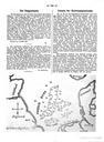
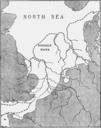
Clement Reid Map Doggerbank. en Map of Doggersbank North Sea showing approximate Coastline at the period of the lowest Submerged Forest Clement Reid Submerged Forests Clement Reid other fields map historical palaeogeographical map PDold Holocene geography Palaeogeographic maps of the Netherlands Doggerland Submerged forests Maps


