
Related Images


Download:
| Tiny | 129x128 | View | Download |
| Small | 259x256 | View | Download |
| Medium | 519x512 | View | Download |
| Large | 1039x1024 | View | Download |
| Original | 9968x9824 | View | Download |
This image was acquired from
wikimedia. It was marked as Public Domain or CC0 and is free to use. To verify, go to the source and check the information there.
Looking for more info about this image?
Try a Google Reverse Image Search for it.
Try a Google Reverse Image Search for it.
Keywords from Image Description:
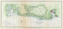
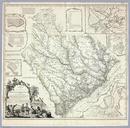
Cook James Map of the Province of South Carolina . Map of the Province of South Carolina with all the Rivers Creeks Bays Inletts Islands Inland Navigation Soundings Time of High Water on the Sea Coast Roads Marshes Ferrys Bridges Swamps Parishes Churches Towns Townships Country Parish District and Provincial Lines Humbly inscribed