
Related Images


Download:
| Tiny | 77x128 | View | Download |
| Small | 154x256 | View | Download |
| Medium | 308x512 | View | Download |
| Large | 617x1024 | View | Download |
| Original | 1292x2144 | View | Download |
This image was acquired from
wikimedia. It was marked as Public Domain or CC0 and is free to use. To verify, go to the source and check the information there.
Looking for more info about this image?
Try a Google Reverse Image Search for it.
Try a Google Reverse Image Search for it.
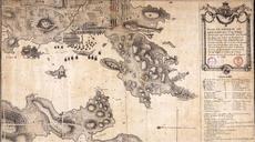
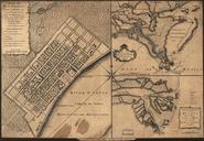
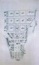
Keywords from Image Description:
Map of French colony of Port Saint Louis Malvinas Islands . es Plano de la colonia de Louis Antoine de Bougainville de Port Saint Louis Puerto Soledad en las Islas Malvinas Martnez Casado Gisela Malvinas nuestro legado francs Buenos Aires Argenta Sarlep pp ISBN Archivos de AixenProvence Centro de Archivos de Ultramar Francia