
Related Images


Download:
| Tiny | 106x128 | View | Download |
| Small | 213x256 | View | Download |
| Medium | 427x512 | View | Download |
| Large | 854x1024 | View | Download |
| Original | 2503x3000 | View | Download |
This image was acquired from
wikimedia. It was marked as Public Domain or CC0 and is free to use. To verify, go to the source and check the information there.
Looking for more info about this image?
Try a Google Reverse Image Search for it.
Try a Google Reverse Image Search for it.
Keywords from Image Description:
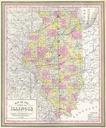
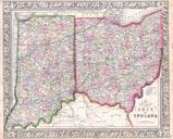
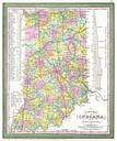
Cowperthwait Mitchell Map of Indiana Geographicus INm. This hand colored map is copper plate engraving dating to by the legendary American Mapmaker Mitchell the elder It represents Indiana Contains notes on steamboat stops and routes between Pittsburg and Louisville and between Louisville and New Orleans Upper portion of the