
Related Images


Download:
| Tiny | 146x128 | View | Download |
| Small | 293x256 | View | Download |
| Medium | 586x512 | View | Download |
| Large | 1173x1024 | View | Download |
| Original | 5000x4364 | View | Download |
This image was acquired from
wikimedia. It was marked as Public Domain or CC0 and is free to use. To verify, go to the source and check the information there.
Looking for more info about this image?
Try a Google Reverse Image Search for it.
Try a Google Reverse Image Search for it.
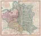
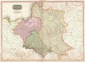
Keywords from Image Description:
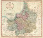
Cary Map of Prussia and Lithuania Geographicus Prussiacary. An extremely attractive example of John Cary map of Prussia Covers from Pomerania eastward along the Baltic Coast as far as Poland extends south to Soldau and north past Lithuania to Memel modern day Klaipeda Offers stupendous detail and color coding according to region