
Related Images


Download:
| Tiny | 150x128 | View | Download |
| Small | 300x256 | View | Download |
| Medium | 600x512 | View | Download |
| Large | 1201x1024 | View | Download |
| Original | 5000x4262 | View | Download |
This image was acquired from
wikimedia. It was marked as Public Domain or CC0 and is free to use. To verify, go to the source and check the information there.
Looking for more info about this image?
Try a Google Reverse Image Search for it.
Try a Google Reverse Image Search for it.
Keywords from Image Description:
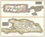
Thomson Map of Guadaloupe Antigua Marie Galante West Indies Geographicus Guadaloupet. fine hand colored map of the West India islands of Antigua Guadeloupe and Marie Galante Depicts the islands in considerable detail with attention to rivers topography towns and villages and major port cities Issued as chart number in the